
CLICK AND HOVER TO FIND AND FILTER KEY TB DATA BY COUNTRIES, TIMELINES, CATEGORIES, AND SO MUCH MORE
25 November 2019 I Geneva, Switzerland – The Stop TB Partnership is proud to announce that its interactive mapping tool is now LIVE.
Anyone can visualize the last five years of critical TB data of any country, compiled from official sources such as the WHO, the Global Fund to Fight AIDS, Tuberculosis and Malaria, the StopTB Partnership and the Institute for Health Metrics and Evaluation. And it's all in one place!
Presented in a user-friendly way, it’s easy to find and compare key TB facts and figures across single or combinations of countries, drilled down by timescales, filtered ranges, categories, numerical scales and much more.
This tool is vital for decision makers, civil society, TB affected communities, NGO’s and agencies, governments, the media and anyone who needs it, to track progress and stay up to date with the TB situation across the globe. It's a major step forward in helping to accurately compare, budget, advocate and better plan for the global fight against TB.
These important numbers are crucial to informing the TB argument, quickly giving everyone the facts and figures they need.
CLICK FOR THE STOP TB PARTNERSHIP INTERACTIVE TB MAPS
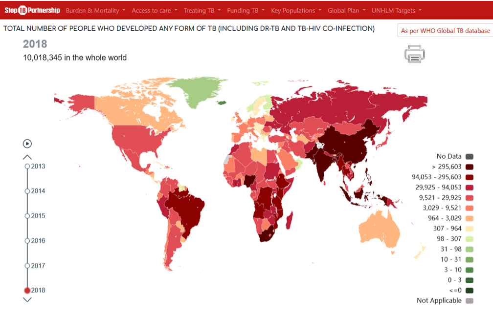
WHAT DO THE STOP TB PARTNERSHIP’S INTERACTIVE MAPPING TOOL & DASHBOARDS OFFER?
The interactive mapping tool is the most comprehensive overview of country data available in graphic form.
There are 64 different categories of maps and graphs covering the last five years of data compiled from WHO, the Global Fund, the Stop TB Partnership and the Institute of Health Metric and Evaluation (IHME).
You can find the following data in a user-friendly format grouped under 7 main categories:
- Burden and Mortality:
- World Health Organization (WHO) estimates of TB, TB-HIV mortality.
- WHO estimates for TB, drug-resistant TB (DR-TB), pediatric TB and TB-HIV burden and rates (incidence per 100’000 population).
- UNHLM TB targets for notifications and preventive therapy (2018-2022) including:
- Notifications Targets for TB, DR-TB and pediatric TB.
- Preventive Therapy Targets for Contacts (below and above 5 years of age), PLHIV.
- Access to Care
- Missing TB, Pediatric TB and DR-TB cases.
- Incidence of missing cases per 100’000 population.
- Notifications for different forms of TB – unpacked by DR TB, Pediatric TB, DS TB.
- Treating TB:
- Treatment Coverage (%) for different forms of TB – unpacked by DR TB, TB-HIV and DS TB.
- Treatment Success (%) for different forms of TB – unpacked by DR TB, TB-HIV and DS TB.
- Funding for TB Interventions:
- Financial Data on TB - including Funding Needs, Domestic Funding and funding from External Donors (Global Fund and USAID).
- Targets for funding for TB research and development - coming soon.
- Availability of TB funding for TB research and development - coming soon.
- Key Populations:
- Data on the size and TB incidence in key and vulnerable populations - coming soon.
- Global Plan:
- Bubble plots showing the time trends of treatment coverage and success for TB, TB-HIV and DR-TB, PLHIV and children 5years in the 30 countries with the highest TB burden.
Click on countries to access the country specific dashboards and hover your pointer over the maps to see them scale up and down, show timelines, filter by rank of values, and much more.
CLICK FOR THE STOP TB PARTNERSHIP INTERACTIVE TB MAPS
The designations employed and the presentation of the material on the maps do not imply the expression of any opinion whatsoever on the part of the Stop TB Secretariat concerning the legal status of any country, territory, city or area or of its authorities, or concerning the delimitation of its frontiers or boundaries. White discontinuous lines are used to represent boundaries under dispute and to approximately show the line of control in Jammu and Kashmir agreed upon by India and Pakistan. The final status of Jammu and Kashmir has not yet been agreed upon by the parties. This map is based on UN Map No. 4170 Rev. 15 (July 2018). Every effort is made to ensure this map is free of errors but there is no warrant the map or its features are either spatially or temporally accurate or fit for a particular use. This map is provided without any warranty of any kind whatsoever, either express or implied.